Assimilating Data Into A Circulation Mode
The objectives are development and testing of a TUNEd NEarshore Prediction model (NEPTUNE) that will combine a nearshore circulation model with observations of the circulation field. The system will consist of an existing numerical model of the depth- and phase-averaged equations of motion governing the temporal and spatial evolution of nearshore circulation, and will utilize video observations of quantities relevant to the circulation. Primarily, observations of surface current patterns obtained using Particle Image Velocimetry (PIV) techniques applied to a video system will be used, but techniques to assimilate video observations of surf zone width, energy dissipation, or radiation stress gradients will also be developed.
Data assimilation methods provide the formal means for combining models with measurements to generate solutions that constitute a best fit to all relevant data while satisfying the constraints imposed by the modeling equations. The focus is on a thorough understanding of the assimilation techniques and their implementation into the circulation model, and testing of the modeling scheme as part of the Nearshore Canyon Experiment (NCEX). Two distinct strategies are being examined:
- Computationally efficient sequential estimators that correct forward model output using available data, but do not tune model parameters (such as frictional coefficients). It is anticipated to model a “strip” of the beach that extends alongshore for several kilometers and is bounded by the shoreline and the 10 m contour in the cross-shore direction (SEE FIGURE 1).
- More computationally expensive inverse models that are used to adjust free model parameters to achieve an optimal fit to the data. Inverse methods are based on the derivation of an adjoint model which propagates information backwards in both space and time. The forward and adjoint models are solved iteratively. This process is outlined schematically in FIGURE 2. Using this technique a portion of the NCEX site, such as the area around Black’s beach (SEE FIGURE 3), will be modeled in detail.
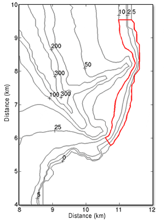
FIGURE 1: Domain of interest for model simulations (outlined in red). The longshore extent of the domain of interest is chosen to coincide with the area that will be viewed with the video cameras. Note that the model domain is bounded by curvilinear lines in the cross-shore direction. The off-shore boundary conicides with the 10m-contour. The location of the shoreline boundary can vary to account for the tidal elevation and any shoreline runup due to low frequency motions.
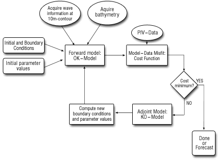
FIGURE 2: Flowchart of an inverse modeling scheme.
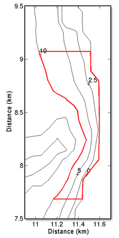
FIGURE 3: Domain of interest for model simulations around Black’s beach (outlined in red)