Rip currents may be an important source of exchange of water and sediment between the surf zone and the inner shelf. The rip current shown above is carrying sediment offshore to water depths greater than 10 m.
The wiggles in the large rip current shown above may be the result of instabilities.
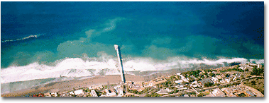
Aerial photograph of complex nearshore circulation near Scripps and La Jolla Submarine Canyons on the Southern California coast. There is a strong offshore flowing rip current to the south (left) of the 340-m long Scripps Institution of Oceanography pier, as well as smaller jets, eddies, and meanders (eg, outside the surfzone (white foam) north of the pier). Recent rains resulted in a strong color contrast between sediment-laden nearshore water and the clearer blue waters farther offshore.
Instabilities And Morphological Response
Rip currents (strong seaward flowing nearshore currents) observed near the submarine canyons (FIGURE 1) exhibit strong meanders that suggest an instability. Cyclonic eddies at the seaward ends of the rips suggest further that nonlinear instabilites may be important to rip current dynamics.
Models for the generation, dynamics, and instability of rip currents and their impact on surfzone bathymetric evolution will be compared with observations. The research plan includes obtaining observations of:
- surface flow patterns over particular nearshore regions extending from the shoreline to beyond the surf zone and over several hundred meters alongshore
- large scale alongshore variations in wave breaking patterns along the extent of the NCEX field site
- large scale bathymetry and beach profile data over the NCEX field site
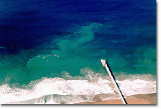
FIGURE 1: Close-up view of a meandering rip current near the Scripps pier made visible by sediment-laden water. The scale of the rip is much larger than the surf zone, and likely is driven by alongshore pressure gradients set up by larger waves to the north and south of the region shown.
The field data will be used to verify numerical models for rip currents and their linear and nonlinear instabilities, and to capture the coincident changes to the large-scale bathymetry in and around rip currents. The data also can be used to verify numerical models for nearshore circulation. Results of this research will lead to an improved understanding of the generation of rip currents in relation to large-scale pressure gradients and breaking patterns, and the impact of rip currents on large-scale bathymetric evolution.
As a consequence of the new field measurements required to examine rip current dynamics, new remote sensing technologies (video Particle Image Velocimetry) will be developed for measuring large scale surface currents in the surf zone.
Lagrangian drifters also will be used to estimate the locations, flow speeds, and offshore extents of rip currents. Circulation patterns from the drifter observations (FIGURE 2) will augment and complement the in situ and remotely sensed measurements.
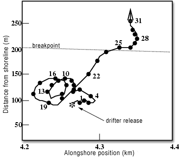
FIGURE 2: Trajectory of a drifter released within the surf zone south of the Scripps pier. The filled circles along the trajectory are spaced 1 minute apart (numbers indicate minutes since release). The drifter made two revolutions suggestive of an eddy motion before moving offshore at 50 cm/s in a rip current. The 60-cm long drifters are tracked in real time with 3-5 m accuracy using differential GPS and a radio link to shore.