The evolution of surface waves propagating across shallow coastal areas is affected by many physical processes, including those related to topography (shoaling, refraction, trapping, diffraction, reflection), nonlinear wave-wave interactions (triad and quartet resonances), and dissipation (wave breaking and bottom friction).
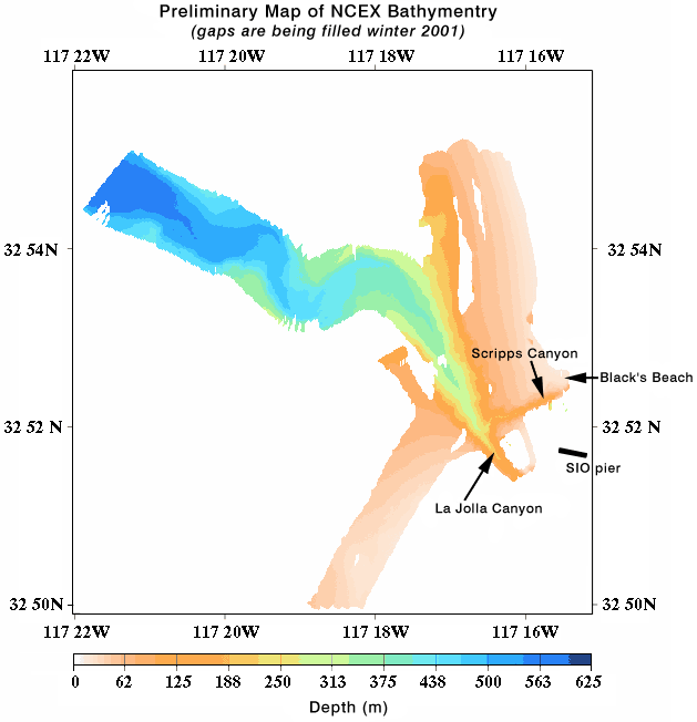
FIGURE 1: results in strong alongshore gradients in wave height and direction
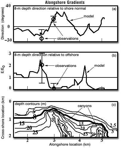
FIGURE 2: Spectral-refraction model predictions in 8-m water depth of wave (a) direction (relative to shore normal) and (b) energy (relative to offshore wave energy E0) for directionally narrow (peak offshore direction 280-degrees) 14 s swell propagating across (c) the abrupt bathymetry (depth contours in m) of Scripps (alongshore location 3.2 km) and La Jolla (alongshore location 4.7 km) Canyons. Preliminary observations (circles are means, vertical bars are +/- 1 standard deviation), acquired between 20 Sep and 3 Nov 2000, confirm the predicted strong alongshore variation of wave direction and energy of 14 s swell approaching from 280-degrees.
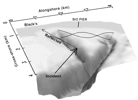
Figure 3: Reflection and Trapping
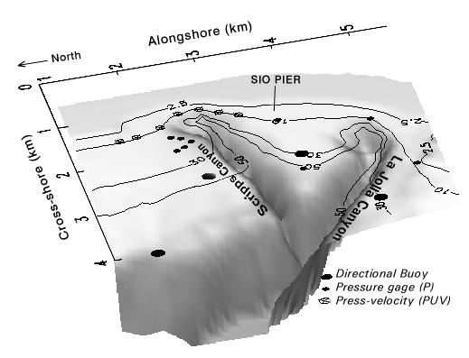
Figure 4: Array Plan for Wave Studies
In addition to refraction and diffraction, the canyon bathymetry also may result in trapping of swell and infragravity waves between the canyon heads (FIGURE 3), and reflection from the steep canyon walls. Reflection of wave energy may result in waves at Black’s Beach (north of Scripps canyon), that are much larger than predicted by existing models.
Hypotheses and models for wave propagation across steep nearshore bathymetry will be tested with observations around, between, and onshore of the canyons (FIGURE 4). The observations along the 10-m depth contour also will be used to initialize models for wave propagation across the surfzone and the resulting breaking-wave driven circulation. Large-scale video imagery (below) will also be available to examine wave propagation patterns throughout the domain.
Large-scale Video Imagery
Digital imagery from an airborne camera system (AROSS) will be geo-rectifed using a unique processing algorithm to allow wave parameters such as wave period and direction to be determined. A data cube of information (two spatial dimension plus time) will be available for durations of approximately 1 hour over multiple coverage areas (see FIGURE 5) up to 3 x 3 km. These data can be used to characterize the transformation of deep-water waves through the surfzone over the complicated bathymetry. In addition, the images are can be used to extend the in-situ observations to the unsampled regions between sensor locations.
» HIGH Resolution (xxmb .avi file)
» LOW Resolution (xxmb .mp4 file)
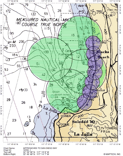
FIGURE 5: The large green circles are deep water collections at 3 m pixel resolution and the smaller purple circles are the surf zone collections at 1 m resolution.